
English| EUR
Suggested for you
More currencies
Choose a language
The Lethe River departure point sits inland in Hanover Parish, roughly 16 kilometers southeast of Montego Bay's hotel zone and 45 kilometers from Negril. Most visitors arrive by rental car or arranged transfer, following the B8 corridor through Montopolis before turning south toward the estate. The route is paved but narrow in stretches, and cellular signal weakens past the main junction.
Quick answer
The Lethe River rafting site is located in Lethe, Hanover, Jamaica, approximately 35 minutes by car from Montego Bay and 75 minutes from Negril. Visitors driving from Montego Bay take the B8 road south through Montopolis, then follow local signage toward the Lethe estate. Taxis and private transfers are widely available from both resort areas, and most hotels can arrange round-trip transport with advance notice.
The Lethe estate occupies a quiet valley where the Great River bends through limestone formations and bamboo groves, far enough from the north coast corridor that the drive itself becomes part of the experience. For travelers staying in Montego Bay, lethe river rafting jamaica directions begin at the Hip Strip roundabout, following the B8 inland past Montpelier and through the village of Montopolis. The route climbs gently through cattle pasture and cane fields before descending toward the river basin, with the turnoff marked by hand-painted signs approximately two kilometers past the Retirement primary school. Rental cars offer the most flexibility for visitors combining the river trip with stops at nearby Tryall Estate or the Rocklands Bird Sanctuary, both within twenty minutes of the departure point. The B8 is well maintained as far as Montopolis, but the final approach narrows to single-lane stretches where oncoming vehicles require careful negotiation. Travelers unfamiliar with left-hand driving or mountain roads often prefer arranged transport, and most Montego Bay hotels partner with licensed operators who include the transfer in packaged itineraries. The estate maintains a small gravel parking area shaded by mango trees, with space for roughly a dozen vehicles. From Negril, the journey follows the coastal A1 east to Lucea, then joins the B8 south toward the interior. The coastal leg offers views of the limestone cliffs and turquoise shallows that define western Jamaica, but the inland portion loses the scenery in favor of practical agriculture and roadside settlements. Budget ninety minutes from Negril's Seven Mile Beach to allow for the slower pace through Lucea and the possibility of livestock crossings on the approach to Lethe. Cellular service from both Digicel and Flow becomes intermittent once the road leaves Montopolis, so downloading offline maps or confirming the route with your accommodation before departure is advisable. The estate's exact GPS coordinates—18.3967° N, 77.9342° W—resolve reliably in Google Maps and Waze, though the final half-kilometer requires attention to the painted markers rather than digital guidance.
“The route climbs gently through cattle pasture and cane fields before descending toward the river basin, with the turnoff marked by hand-painted signs approximately two kilometers past the Retirement primary school.”
Lethe River Rafting is located in the interior of Hanover, Jamaica, accessible primarily via private vehicle or pre-arranged transportation. The site sits inland from Montego Bay, requiring navigation through rural secondary roads.
Follow B6 from Montego Bay towards Lethe
Private hire from Sangster International Airport
Route taxi from Montego Bay Transport Centre to Lethe
The final approach to the Lethe site involves winding rural roads; ensure your driver or GPS is set to the specific Hanover location to avoid confusion with similarly named areas. On-site parking is available for those utilizing rental vehicles.
Lethe River Rafting operates on a consistent schedule throughout the week to accommodate visitors. The site is open daily to provide access to the river experience.
The best arrival window is 09:00–14:00. Arriving within this timeframe avoids peak afternoon heat and potential crowds for a more tranquil experience.
—
Quiet conditions allow for a peaceful journey on the water.
Warm and dry, 26°C to 29°C
Clear skies and stable river levels characterize these popular months.
Humid with occasional rain, 27°C to 30°C
Expect lush surroundings, though brief afternoon showers may occasionally affect operations.
Verdict: For the most tranquil experience, aim for a weekday arrival between 09:00 and 11:00 during the drier months of April or October.
Complete these steps before departure to ensure a smooth arrival and experience on the river.
Everything you need to know about lethe river rafting jamaica directions
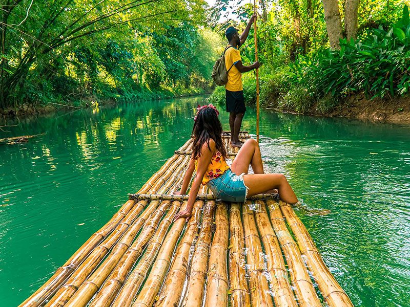
To find the site, navigate toward the village of Lethe in the Hanover parish of Jamaica. Using reliable map applications with the coordinates for Lethe, Hanover, will provide the most accurate path to the riverbanks. Local taxi services and private transfers from Montego Bay are often the most straightforward methods for reaching the location. Public transit options in rural Hanover are limited, so most visitors prefer private transport or organized shuttles when planning lethe river rafting jamaica directions. Booking a private transfer ensures you reach the bamboo raft boarding area without navigating complex local roads. Relying on professional drivers simplifies your journey, as they are accustomed to the scenic, winding routes throughout this part of the island. When following lethe river rafting jamaica directions, rental car users should prepare for narrow, mountainous roads that require cautious driving. Ensure you have offline maps downloaded, as mobile signal can be inconsistent in more remote sections of the Hanover parish. On-site parking is available for guests arriving by car near the raft launch point. Following the recommended lethe river rafting jamaica directions allows for a stress-free arrival. We suggest checking your departure timing to account for local traffic conditions, ensuring you arrive well within the optimal morning window for a tranquil experience.